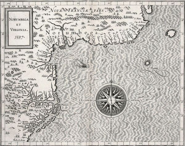
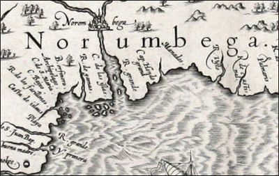
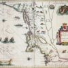
Norumbega et Virginia,1597
Mapmaker: Cornelis Wytfliet
This first atlas devoted entirely to the Western Hemisphere is aptly named after Ptolemy, the Ancient cartographer whose Geographia was rediscovered in the Renaissance and first reprinted in Bologna in 1477. Wytfliet’s atlas, a compendium of information from others’ maps, is a history of the New World to date, including discovery, history, geography, natural history, etc. The 19 maps focus on the continents’ coastal regions, leaving the clear message that information about the unknown interiors was pure speculation. (The Victorians were not the first to need to fill empty spaces!) One of the maps, Norumbega et Virginia, represents the best information about the area to date. It also continues the omissions and errors of de Jode and Quad: no Hudson River, no New York Bay, still no Long Island.
Norumbega is a mythical place, a name possibly taken from an Abenaki Indian word for quiet water between two falls or rapids. The name first appeared on Gestaldi’s map of New Spain, 1548. Venice, the city recorded on the map, stands at the head of today’s Penobscot Bay, Maine. Champlain journeyed there to find it, without success.
Still not much information here to encourage one about the yet-to-be New Netherland, but the ship in mid-ocean reminds us that we are on our way (although it is not a seaworthy vessel)!

Norumbega et Virginia, 1597
This primitive map of the coast near what would become New Netherland contains little information that would be useful to explorers, and any information about the interior is pure speculation. Its omissions are apparent: no Hudson River, no New York Bay, still no Long Island. The amount of information known to cartographers would increase exponentially over the subsequent decades.
Norumbega Coast Detail
This detail shows the ommission of many important details like the Hudson River and Long Island.
The Maps of
Charting New Netherland
01
This map from Quad’s general atlas of the world, an expansion of his 1592...
02
This first atlas devoted entirely to the Western Hemisphere is aptly named after Ptolemy,...
03
This 1630 map by Johannes de Laet marks a cultural and cartographic shift from...
04
This map of New Netherland and New England, based on Adrian Block’s 1614 chart,...
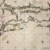
05
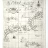
Mapmaker: Robert Dudley Tinting (adding color) either contemporaneously or later has always been a...
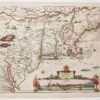
06
Mapmaker: Nicolaes Visscher The Jansson-Visscher series of maps of New Netherland and New England is...
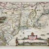
07
Mapmaker: Justin Dankerts This third-generation example of the Jansson-Visscher series is most lavishly decorated....
08
Mapmaker: Johannes van Keulen The part so far left out of this tale of...


