
Pieter Dirkszoon Keyser and the Mapping of the Southern Sky
On a warm, cloudless night in February I walked into the rustling garden of my friends’ house and looked up at the sky. What I saw up there wasn’t a complete surprise, and yet it was still striking, and very strange to me. Despite the lights of the city I could see plenty of stars, and yet I was unable to link them together into any discernable pattern, as I was so used to doing at
home. The simple reason for both my awe and my confusion was that I was in Auckland, New Zealand. This was the southern sky, presenting me with an unfamiliar clutter of stars.
by Peter A. Douglas
Standing on solid ground though I was, this, I thought, was how it must have been for those early maritime explorers, those who sailed below the equator, plunging bravely southward and finding that even the night sky was as mysterious as the unknown coasts they hoped to find. Like me, they’d spent their lives in the north, and knew well the constellations of the northern night, so familiar to sky-watchers for thousands of years. This northern sky is full of these old friends — Orion, Cassiopeia, Cygnus, Taurus, Leo, and especially Ursa Major, the Great Bear, pointing the way to Polaris, the North Star.
The old navigators’ southward passages were literally uncharted, the universe still blazing but unhelpfully devoid of these well-known star gatherings to use as a sea map. Up there above Auckland were the scattered groupings that others had grown up with, a celestial hotchpotch that had been given more modern, practical, and to me far less evocative names. Here it was impossible for me to connect the dots.
 I did know, however, the appearance and approximate location of the one special grouping that I was looking for. And there it was, not quite on the celestial pole but close enough, and sufficiently outstanding to guide those ancient sailors who came to map the new heavens as well as the new lands. It was as much a thrill for me to see it, as it must have been for them, the four bright and compact points of Crux, the Southern Cross. I recalled reading that Ernest Shackleton had relied on this handful of stars on his desperate 700-mile voyage from Elephant Island to South Georgia in 1916. This star alignment has acquired a high level of cultural significance in many Southern Hemisphere nations, territories, and states, and appropriately its brightest stars appear on the national flags of New Zealand, Australia, Brazil, Papua New Guinea, and Samoa.
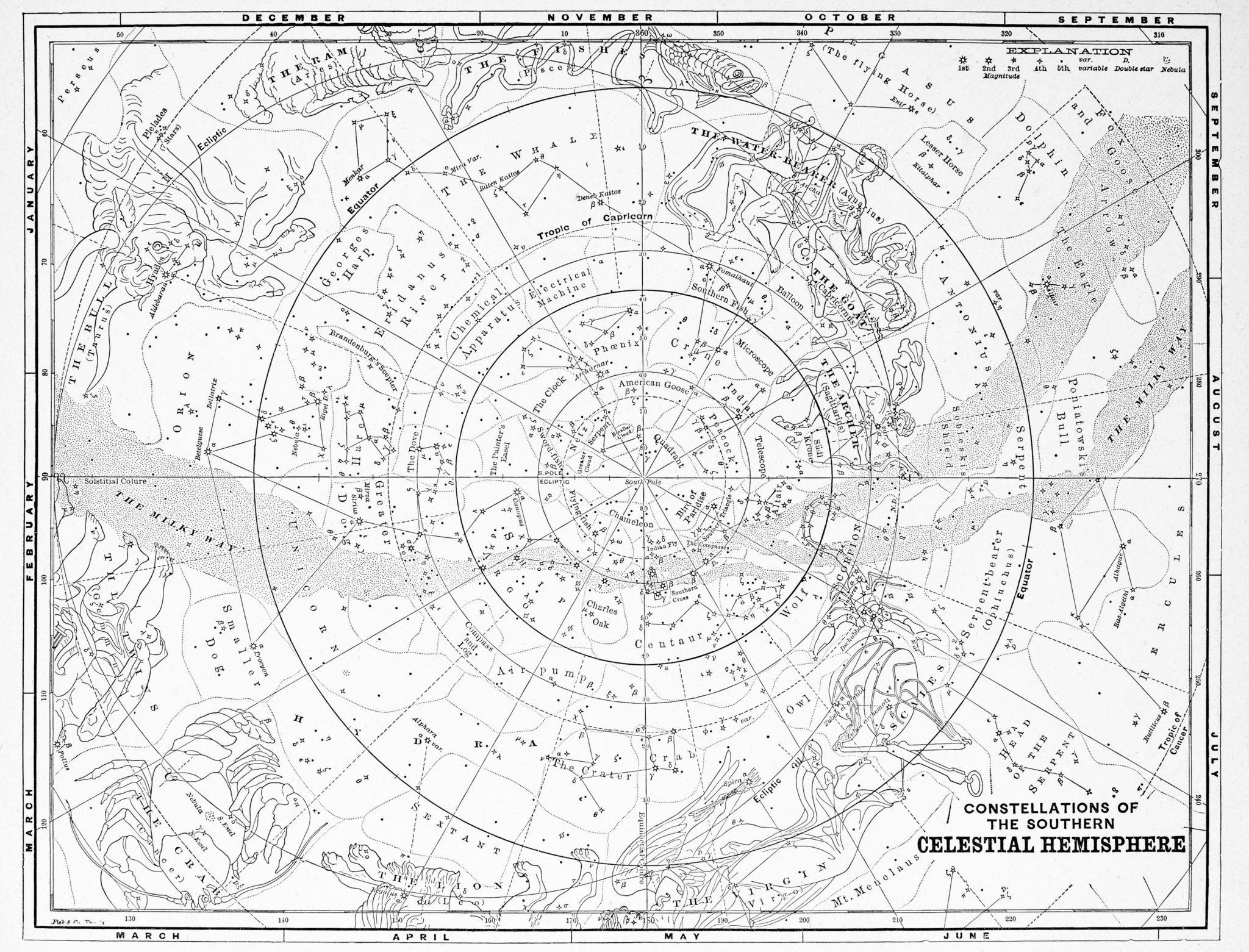
If you’re in the north and far enough south, around 35 degrees latitude, you can see the Southern Cross, but most of the southern stars are invisible north of the equator, and so were never observed or catalogued by the ancient Babylonians, Greeks, Romans, Chinese, or Arabs. There are now eighty-eight constellations in the entire night sky, as recognized by the International Astronomical Union, a total that has grown from the forty-eight classical Greek constellations set out by Ptolemy in his Almagest in the second century AD. Not surprisingly, Ptolemy’s catalog comprises only the stars visible at the latitude of Alexandria, where he lived.
This work remained the last word on the constellations until the sixteenth century, when European voyages of discovery took navigators into southern latitudes. Many such voyages were made in the late fifteenth and early sixteenth century, and although these first explorers must have observed and made use of the new southern stars, no one seems to have made an attempt to record or constellate them. This was left to a Dutch navigator at the end of the sixteenth century, though today his name is barely known.
The connection may not at first be obvious, but we owe the first mapping of the extreme southern part of the celestial sphere to the commercial rivalry between the Netherlands and Portugal in the lucrative spice trade. The first Dutch voyage to Indonesia, known as De Eerste Schipvaart, took place from 1595 to 1597, and it was Pieter Dirkszoon Keyser (1540-96), (sometimes known as Petrus Theodorus, or Peter Theodore) the chief pilot of the expedition, who made the celestial observations.
Instrumental in the planning of this first voyage was a Flemish astronomer, cartographer, and theologian called Petrus Plancius, born Pieter Platevoet in Dranouter in 1552. Plancius was a keen promoter of the Dutch East Indies expedition and also an expert on the shipping routes to the Indies. He saw the 1595 expedition as a means not only to open up the Dutch spice trade but also to gather astronomical information on the far side of the equator. To that end Plancius urged Keyser to map the heavens while he was on the southern seas. Among the crew on this voyage was Frederick de Houtman (1571-1627), sub-commissioner in the mercantile part of the expedition.
The fleet that left Texel in April 1595 comprised four ships: Mauritius, Amsterdam, Duyfken, and Keyser’s ship, Hollandia. The voyage was a difficult one, and when ships arrived in Madagascar in September more than a quarter of the ships’ complement had died. They were obliged to remain in Madagascar for several months to recover and make repairs, and it was at this point that Keyser probably made most of his celestial observations, and perhaps in Sumatra too. The fleet reached East Indies in June 1596. Three months later Keyser died.
Getting back home was a rough trip too, and after many adventures and misadventures, what remained of the fleet arrived back at Texel in August 1597. Only around a third of the crew survived. The cargo of spices was meager and the expedition was hardly a financial success, but it proved that trading voyages to the Indies via the southern tip of Africa were feasible. Five years later, in 1602, the Dutch East India Company was established.
Frederick de Houtman survived, and he delivered Keyser’s star observations to Plancius. These included 135 stars arranged into twelve new constellations, which Plancius included in his new celestial globe in 1598, created with the cooperation of the engraver and cartographer Jodocus Hondius. Some say that the new constellations were the work of Plancius, though their given names do suggest Keyser’s work, for clearly he must have been impressed by the fauna he encountered on the voyage as most of these constellations represent the exotic animals, fish, and birds of the regions he explored. The modern names for these new constellations recorded the new things that European explorers found, and they had no mythology behind them. These are some of them: Apus (Bird of Paradise), Chameleon, Dorado (Golden Fish), Grus (Crane), Hydrus (Water Snake), Indus (Indian), Musca (Fly), Pavo (Peacock), Phoenix, Triangulum Australe (Southern Triangle), Tucana (Toucan), and Volans (Flying Fish).
From this point on we hear little more of Keyser, a fact not helped by his death in 1596, though his constellations took root and appear in the star charts of later astronomers. As for Frederick de Houtman, his name has survived, and has always been linked with Keyser’s in the depiction of the southern constellations. They are usually credited jointly with the work, though de Houtman’s contribution (and even his actual participation) has been questioned.
By 1619 de Houtman was exploring the western coast of Australia, but much of his reputation derives from the publication in 1603 of his Malay and Madagascan vocabulary, at the end of which he included, as an unusual appendix, a catalogue of the southern stars—the first such catalogue ever made. It consists of the right ascensions, declinations, and magnitudes of 303 stars, 196 of which were newly discovered. The new stars are distributed among twenty constellations, most of which are those that Keyser observed and noted in Madagascar, though nowhere does de Houtman give any credit to Keyser for his prior work. To de Houtman went the kudos, while from the grave Keyser could make no challenge.
De Houtman declared that he made the observations during his first voyage (the 1595-97 expedition) and revised his findings on his second voyage to Sumatra, starting in March 1598 when he was in command of the Leeuwin. However, three twentieth century astronomers have cast doubt on the legitimacy of de Houtman’s claim that the details in his 1603 star catalogue came from his personal observations, and there are good reasons for assuming he used those of Keyser. On the first voyage de Houtman was sailing in a purely commercial capacity, and was only twenty-four years old, whereas Keyser was in his fifties, and a seasoned navigator too. Other circumstantial evidence in de Houtman’s busy life at the time (including being imprisoned in Sumatra for many months on this second voyage) suggests that he had little leisure or opportunity to engage in the complex task of celestial observation, even if he had the ability.
A particularly persuasive piece of evidence that condemns de Houtman as a plagiarist was the discovery of an inscription on a Hondius celestial globe dating from 1600 that states in Latin: “A celestial globe on which are most accurately marked all of the fixed stars which the nobleman Tycho Brahe observed so industriously and carefully, as well as the southern circumpolar stars which were observed by the most learned navigator, Peter Son of Theodore, student of mathematics.”
The irresistible conclusion is that de Houtman misappropriated Keyser’s work and took the credit for it, and that the honor of being the first to observe and delineate the stars of the southern pole belongs solely to Keyser. Regrettably little else is known of his life and achievements, but his astronomical legacy is forever. So Pieter Dirkszoon Keyser can be included with those Dutchmen whose names, for all their courage, merit, industry, and accomplishments, have long and unfairly lived in history’s shadows.