Lost Ships of the VOC
“They that go down to the sea in ships, that do business in great waters;
These see the works of the Lord, and his wonders in the deep.
For he commandeth, and raised the stormy wind, which lifteth up the waves thereof.
They mount up to the heaven, they go down again to the depths:
their soul is melted because of trouble.”
Psalm 107, 23-26
by Peter Douglas
There are many ways to “lose” a ship, and the VOC saw them all. The Vereenigde Oostindische Compagnie (VOC), the Dutch East India Company, a chartered company created for trade with the East, had hundreds of ships sailing the oceans of the world for two centuries. According to Mike Dash in his 2002 book Batavia’s Graveyard, (page 238): “During its two hundred year history, the VOC lost one in fifty of its ships outward bound, and nearly one in twenty on the return voyage, a total of 246 vessels.” He adds: “At least three of these ships, and possibly as many as eight or ten, were shipwrecked along the western [Australian] coast.”
The fates of the ships in the VOC fleet include the many predictable maritime disasters—those that the dangers of the sea easily brought to vessels of wood, rope, and canvas,and were thus more at the mercy of the elements in the days before steel hulls, self-propulsion, radar, and satellite navigation—as well as those attributable to enemy action and the predations of pirates and privateers. Ships were wrecked for many reasons. They ran aground, they sank in storms, they were destroyed by fire (accidental and otherwise), they broke up on rocky coasts, they were seized by an enemy, they were blown up in battle, or by the ship’s own powder, they were abandoned as unseaworthy, they capsized, and they sank because of leakage. And unlucky ships could also be fatally damaged by a living hazard: shipworms, or teredo navalis, often called “termites of the sea,” a marine mollusk that burrows into wood and so threatens the structural integrity of a ship. The VOC was conservative, and was late adopting the practice of copper sheathing ships’ hulls, which offered some protection against this. It was only in 1792 that the VOC requested (but did not require) all new ships to be copper-bottomed. This wasn’t made compulsory until 1794.
Tragedies all, these reasons for losing a ship, for the crews and passengers especially, and for the owners and investors whose rich cargoes ended up deep on the ocean floor, scattered among the reefs and rocks of distant atolls and foreign shores, or in the holds of enemy or rival ships. Despite the known and varied perils of navigation in centuries past, unless a disaster took place in the middle of the ocean, people back home could still eventually be made aware of the wreck of a ship in various ways—from survivors’ tales, from witnesses ashore or on other ships, and by enemy captains. Reported details of shipwrecks usually contained some geographical information or some other scrap that could provide a little comfort to others, who might at least know some sad detail of their loved one’s end, or what became of their precious merchandise. Every wreck is a catastrophe, but the small saving grace of such fates was that the ships’ fates might be at least known, sooner or later, to the survivors’ or victims’ families, and to the city fathers whose guilders sponsored the voyage. Given how much bigger and less connected the world was in the seventeenth and eighteenth centuries, word of a shipwreck getting back to the port of origin was far from guaranteed, but it did happen.
Mike Dash wrote of the VOC’s “lost” ships. Sometimes “lost” and “wrecked,” mean the same thing—sometimes not. The loss is known; the wreck is an assumption. Ships that were wrecked were certainly “lost,” but rarely in the sense that we don’t know where they are. Most tragic of all is when no one knows what happened—when a ship sails away and is never seen or heard from again. A ship that’s “lost” in battle, or because it ran aground and broke up on the Isle of Wight or on the rocks of Caithness, is not really “lost” in the broader meaning except to its crew, its country, or its owner. The ship no longer exists as a floating vessel, but we know why, and we know where it is.
The other kind of “lost” in the maritime sense is when a ship just vanishes between ports—when it sails off over the horizon and fails to arrive at its destination. When it simply disappears without trace, it is then truly lost. In such cases one has to eventually believe the ship was wrecked or sunk, but all that’s known is that it was “lost,” somewhere, perhaps, in the more than 27 million square miles of the Indian Ocean, and cannot ever be found or recovered.
When a voyage to the Far East would take many months, or even up to a year, at what point do those ashore start to worry? Of course, worry would have been a way of life for all those connected in any way to those sailing the high seas, then as now, but especially in a world less understood in every way. For people sailing the wild oceans in ships made from trees and tarred hemp, life was fragile and the anxiety constant. When your husband, brother, or father is sailing from the Netherlands to Batavia, you don’t count on seeing him for at least two or three years. The lack of news would be normal, and life would carry on until the sailor returned—or never did. This kind of “lost” takes a while to become apparent. The hazards of the sea can create natural delay for many reasons other than a real disaster, and sanguine expectations would hold sway for a while. A ship might lose a mast and put in somewhere for an urgent repair. It might be becalmed. The crew might get sick with scurvy or other diseases. A strong contrary wind or current might retard its progress. Weeks or months would have to pass after the date of a ship’s expected arrival before hope would entirely fade away, and there would be no closure.
Of the many truly “lost” VOC retourschips—East Indiamen strongly built for long ocean transport between the Netherlands and the East Indies—the most discussed are the three that vanished between 1694 and 1726, and will be examined below. The assumption is that they were wrecked off western Australia, but this is not proven.
The assumption holds firm even without any hard proof because the western coast of Australia became a notorious graveyard for ships after the adoption of the “Brouwer Route,” a fast new route to the East Indies proposed by the Dutchman Hendrik Brouwer in 1611, making use of the “Roaring Forties.” These strong westerly winds, between latitudes 40 and 50 degrees south, blew the ships from southern Africa towards Australia at greatly increased speed compared with the old route through the Mozambique Channel, or to the east of Madagascar, and northeast across the Indian Ocean, sometimes via India or Ceylon. The new route shaved months off the travel time between the Netherlands and Batavia. The benefits of this are obvious—shorter voyages meant less wear and tear on both ships and their crews, and hence fewer expenses. For the company, a faster turnaround meant faster profits and lower overheads.
However, these big advantages were offset by equally significant difficulties stemming from there being no accurate way, before the availability of a reliable marine chronometer in the mid-eighteenth century, to determine longitude—that is, to figure how far east a ship had sailed on this route. It was vital at the right point to head north to the Indies, so knowing your ship’s position was important. A successful voyage very much depended on the navigational skill of the captain, who had to know when his ship had reached that crucial point. The captain used astronomical observations and dead reckoning—the process of calculating the ship’s position by estimating the direction and distance traveled. The captain’s only visual cue on this route to help him know his position in preparation for steering north was a sighting of either of two landmarks: Île Amsterdam or Île Saint-Paul, at 37ºS 77ºE. These islands are 53 miles apart, and roughly equidistant from Madagascar, Australia, and Antarctica, about 2,000 miles from each. They are remote and easy to miss, the larger being only six miles long.
Batavia lies at 106ºE, so to be safe a VOC ship should have started heading north somewhere between 90ºE and 100ºE. At 40ºS the distance between degrees of longitude is 53 miles, so turning at 100ºE a ship bound for Batavia had an easterly leeway of only 318 miles. The Australian coast lay at a safe distance for a good navigator, almost 700 miles to the east. Dirk Hartog Island, Australia’s most westerly island, lies at 113ºE—several degrees too far. Miscalculating longitude could mean overshooting the essential turning point, and the consequence of this error was that ships could blindly sail too far east and be wrecked on the treacherous rocks, reefs, and offshore islands of western Australia—a place virtually unknown to European navigators at the time.
Four VOC ships are known to have to have been wrecked here: Batavia (1629), Vergulde Draeck (1656), Zuytdorp (1712), and Zeewijk (1727), and it’s possible that, as with the Batavia, there may have been survivors cast ashore from the other lost ships. As Mike Dash points out, “By 1728 … sailors from at least four retourschepen had been cast upon the Australian coast. These men found themselves stranded in an utterly alien environment, distant from everything they knew and held dear, and with absolutely no prospect of ever seeing Batavia, let alone the Netherlands, again.”
Life at sea in the age of sail was hard, for crew and passengers alike. Sailors endured the obvious dangers of sea and weather, cramped and unhealthy quarters, the risk of disease, poor diet, hazardous working conditions, harsh discipline, and separation from life ashore for months or years. And this was how it was when everything went well. The terrible idea of losing the ship they called home must have always been at the back of their minds, their fate out of their control and slim chances of survival decided in great part by where the wreck took place – polar regions or the tropics — even if they weren’t drowned in the disaster itself.
Mike Dash reflects on how it must have been for the men of those lost Dutch ships, wrecked upon the Australian shore: “Few of them would have had any understanding of exactly where they were; the sheer extent of the land, its harshness, its people, and its unique wildlife were all quite unknown in this period, and few of the survivors would have had any good idea of just how far away they were from safety, or of the enormous physical barrier separating them from their destination. The majority of them probably died close to the spot where they had come ashore, running out of food or water, or murdered by the local people while awaiting a rescue ship that never came.”
The author conjectures further that some probably died making a doomed effort to travel north, the obvious direction to try despite the vague understanding of their whereabouts. In the 1790s prisoners escaping from the British penal colony in New South Wales hoped to walk to China, which they believed was just beyond the mountains northwest of Sydney Cove. The seventeenth century Dutch sailors probably had no clearer concept of antipodean geography. They would have had no idea of the conditions they would face, or the distance to anything resembling safety or familiarity. Batavia was more than 1,800 miles away, beyond the immense desert and across the sea. The absence of any realistic hope of deliverance would naturally soon follow. They would have been in the unwelcome position of being fully aware of the extremity of their situation – “15,000 miles from the windmills and canals of Holland.”
The fate of the three other ill-starred ships is unknown for they were lost without trace. These are: Ridderschap van Holland (1694), Fortuyn (1723), and Aagtekerke (1726). All three ships disappeared sailing from the Cape of Good Hope to Batavia, so we at least know in which vast ocean their bones lie, but that’s all.
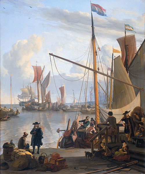
The Ridderschap van Holland (Knighthood of Holland) belonged to the VOC’s largest class of ship—164 feet long, with a beam of 40 feet, and carrying 36 cannon. It was an old ship, built in Amsterdam in 1681 and was thus thirteen years old when it vanished. It had already made four voyages to Batavia, and her fifth and final trip began on July 11, 1693, when she left the Netherlands under captain Dirk de Lange, with a complement of 325. This included two passengers, a Scotsman called Sir James Couper, a wealthy landowner who was traveling with his young son and returning to Batavia to take up an appointment as a member of the Council of the Indies, the VOC’s governing body in the East. The Ridderschap van Holland arrived at the Cape of Good Hope on January 9, 1694, and remained there until February 5 when it resumed its journey, having taken on an additional cargo of wheat. It failed to arrive at its destination and was never seen again.
With the ship seriously overdue, after long deliberations by the VOC directors, in May 1696 the Dutch sea captain Willem de Vlamingh was put in command of a search and rescue mission as it was believed that the Ridderschap van Holland must have foundered off the coast of New Holland, as Australia was known then. Although the ship had disappeared more than two years before, not all hope had been abandoned of finding her and her crew. De Vlamingh commanded the Geelvinck, along with the Nijptang, captained by Gerrit Collaert, and the Weseltje under de Vlamingh’s son Cornelis.
Traveling via the Brouwer Route from the Cape, the flotilla reached the Australian coast at the end of December, having checked out on their way east the Île Amsterdam and the Île Saint-Paul, but found no wreckage or survivors there. North of Fremantle they found wreckage that likely belonged to the Vergulde Draeck, but de Vlamingh’s mission was unsuccessful in finding the lost ship he sought. This is no surprise really, given the many hundreds of miles of rugged Western Australian coastline, along with numerous offshore islands and reefs, but he did explore and map a great length of the New Holland coastline from Rottnest Island to the North West Cape.
Other theories for the ship’s fate included it having put in at Madagascar for repairs to one of the masts and fallen foul of the pirates there, or met with some other peril. It has been said that when the Ridderschap van Holland arrived at the Cape one its masts was sprung. The skipper ordered a new one but Sir James Couper, the senior company official aboard, is said to have countermanded this order in his haste to get to the Indies. The weakened mast might have forced de Lange to steer for the closest land, Madagascar, where the ship could have been lost. Fort Dauphin, on the southeast corner of the island, was a notorious pirate stronghold, and because Dutch ships generally avoided it de Lange may not have been aware of that. But even if he knew, in an extreme emergency the captain may have decided to take a chance. Anyhow, the story seems a bit suspect—how likely is it that Couper would have so compromised his own safety and that of his son? Moreover, no Dutch ships are recorded as having been wrecked on Madagascar between 1694 and 1700.
It’s probable that this ship was indeed wrecked off Western Australia, anywhere between Perth and the Tropic of Capricorn, but a likely spot is in the Pelsaert Group, the southernmost of the Houtman Abrolhos islands. This is a 60-mile long north-south chain of 122 islands and associated coral reefs some 50 miles off the coast near Geraldton. Frederick de Houtman, sailing for the Dutch East India Company, discovered these islands in 1619. He caught sight of the Australian coast near present-day Perth, and proceeded northwards up the coast, encountering—and narrowly avoiding—a group of sandbars and shoals he dubbed the Houtman Abrolhos.
The word abrolhos is Portuguese, making it one of only two Australian place names from this language. The other is Pedra Branca, a 6-acre islet 16 miles off the southern coast of Tasmania, discovered by Abel Tasman in 1642, and named for its resemblance to another “white rock” (from bird droppings) at the eastern end of the Singapore Strait. Proponents of the theory that the Portuguese discovered Australia have argued that the name Abrolhos is evidence that the Portuguese charted these islands in the sixteenth century, and that de Houtman possessed maps resulting from this expedition, though there is very little to support this speculation.
Folk etymology has suggested (though dismissed) that Abrolhos comes from the Portuguese abra os olhos, meaning “open the eyes,” which of course is excellent advice when sailing in dangerous waters. More likely is the fact that abrolhos means bristles, thorns, and thistles—a good name for the treacherous spiky obstructions in the sea that de Houtman skirted. Several theories have been posited to try to explain why a Dutchman would give these islands a Portuguese name. They may have been named after the Abrolhos Archipelago off the coast of Brazil, which de Houtman would have been familiar with. Also de Houtman was an accomplished linguist, and is noted for the first Dutch-Malay and Dutch-Malagasy grammars and dictionaries, so a facility, or at least a familiarity, with Portuguese is quite likely, and the striking foreign word may have appealed to him more than the ordinary Dutch.
The Houtman Abrolhos are well known in maritime history as the site of many wrecks, the most famous being the Batavia in 1629 and the Zeewijk in 1727. The shipwrecked crew of the Zeewijk found the remains of a Dutch ship of around the right age to perhaps be the Ridderschap van Holland, though there was no evidence to identify the ship.
The 1720s were disastrous for the VOC in terms of ships lost. In 1722 alone, five were wrecked in a storm off the Cape of Good Hope, and six were lost in another tropical storm near Mauritius. It has been conjectured that some of these ships may have been lost due to poor design or unseaworthiness. In the early eighteenth century the VOC began constructing broader ships to carry more cargo, despite concern that this redesign changed the ships’ center of gravity and produced more extreme pitching and rolling that contributed to the ships being more sluggish and potentially unsafe.
Between 1723 and 1727 three ships were lost between the Cape and Batavia—Fortuyn in 1723, Aagtekerke in 1726, and Zeewijk in 1727. They were all on their maiden voyages from the Netherlands to the Indies. The only one of these whose fate is known is the Zeewijk, which was wrecked on the Houtman Abrolhos on June 7, 1727, having left Vlissingen the previous November. The wreck was found and positively identified by divers in 1968. No one knows what happened to the other two ships.
The 800 ton, 145 foot long Fortuyn, owned by the Chamber of Amsterdam, sailed from Texel on September 27, 1723, under the command of Captain Pieter Westrik with a crew of 225. Two ships, Hogenes and Graveland, accompanied it. Fortuyn reached the Cape of Good Hope on January 2, 1724, and set out for Batavia on January 18 accompanied by three ships: Hogenes, Doornik (the Dutch name for the Belgian town of Tournai), and Anna Maria. The ships got separated, and two arrived at Batavia, but the Fortuyn was never heard of again. The Graveland, which set sail for Batavia two weeks after Fortuyn, found floating remnants of a ship in April at latitude 13°20´ south, in the vicinity of the Cocos Islands, a small archipelago midway between Australia and Ceylon (Sri Lanka), and some 900 miles from Sumatra. Later an expedition from Batavia went there to search, but found nothing.
The other lost ship referred to above is the 850 ton Aagtekerke (Agatha’s church), built in 1724 by the Zeeland Chamber of the VOC. It carried the same name as that of an earlier ship that had been lost at Plymouth in 1721. After the second loss, the directors of the VOC must have decided that the name brought bad luck, as it was never used again for a company ship. Both ships were named for the nearby town of Aagtekerke and both were lost on their maiden voyage. On May 27, 1725, the Aagtekerke left Vlissingen for Batavia under Captain Jan Witboom with a cargo of silver coins and bullion valued at 200,000 guilders and a crew of 212 men. She reached Cape Town on January 3, 1726, and set sail for Batavia on the January 29, and that was the last anyone saw of her.
As with other lost ships taking this route, she is presumed wrecked on the Houtman Abrolhos, another victim perhaps of the recurring navigational blunder. But without any kind of proof of that fate, she could have succumbed to any of the score of calamitous things that can happen to a sailing ship in a rough sea. In 1840, Commander John Wickham and Lt. John Lort Stokes in HMS Beagle surveyed much of this coast of Australia, but discovered nothing to support the case for the Aagtekerke having been wrecked on or near these shoals. Of course, good evidence in the form of a century-old wreck would have been very hard to find. No solid confirmation of her wreck, or any other information at all, has come to light about this ship’s fate, and so she took her story to the bottom with her. She is one of the truly lost.
Eternal Father, strong to save,
Whose arm does bind the restless wave,
Who bids the mighty ocean deep
Its own appointed limits keep;
O hear us when we cry to Thee
For those in peril on the sea.
The “Navy Hymn.” William Whiting of Winchester, England,
wrote the original words as a poem in 1860.